DID WRITING ORIGINATE IN THE VALE OF GLAMORGAN?
Based on a talk given by Peter Sain ley Berry to the 41 Club, Duke of Wellington Inn, Cowbridge, 10 July 2006
Introduction
Mr Chairman, my thanks to you and the 41 Club for this welcome invitation to speak about my Neolithic researches. Let me start by admitting that the question I pose in the title to this talk is somewhat tabloid and rhetorical. I had to hook your interest somehow. Nevertheless, I do believe that there is at least a possibility that writing could have originated, if not in the Vale of Glamorgan itself, then in that Neolithic society of which people living in the Vale of Glamorgan formed a part. At this moment that proposition may seem quite incredible to you. I hope after I have finished that it may seem less so.
I am not going to present you with examples of Neolithic writing. So far as I am aware none has ever been found. Instead I shall show you some examples of what the Neolithic people did, in the Vale of Glamorgan and elsewhere, and then pose the simple question - is it possible that these people could have done what they manifestly did do, without the ability, in some form or other, to read and write.
Now in supposing that writing did originate among the Neolithic peoples some 6,000 years ago I am not arguing that writing did not originate elsewhere as well.
The concept of writing, expressing thoughts through some species of pen or brush stroke, is not very difficult, after all. When we compare Chinese pictograms, Egyptian hieroglyphics, and our own script system of letters, it is surely easier to imagine that they originated independently of one another rather than being branches of the same evolutionary tree tracing back to some primordial sage who 'invented' the art of writing.
Writing probably originated in various places at various times; branches of writing probably appearing and disappearing as civilisations rose and fell.
I think we can make a credible argument that one of writing's origins lay probably within that great Neolithic civilisation that endured, stable, for several thousand years and which stretched down the Atlantic seaboard of Europe from Scandinavia to Spain. One of the prime centres of this civilisation, where writing might well have developed, appears to have been western Britain including, of course, and for a specific reason that I'll come to in a moment, the Vale of Glamorgan.
The argument is simple: it is well known and accepted that the Neolithic people were sophisticated builders, quarrying and raising great rocks to construct burial cairns and stone circles. They built the great complexes at Carnac in Brittany and Stonehenge in Wiltshire with such precision that they stand as monuments, even today, to human endeavour and ingenuity.
One might suppose that even to do this would have created the need to write. For the people who designed these structures were unlikely to have been the same people called upon to labour over their building. Instructions must have been given about location, dimensions, angles and so on. People must have measured and calculated. Much easier if you have some form of script, even rudimentary.
But of course the Neolithic builders did much more than just that. As I shall show in a moment, they measured and they surveyed. They created units of measure like the pole and the acre, based (incredibly but irrefutably) on the circumference of the earth. And using these measures, they placed their principal sites with great precision in the landscape relating them to geographical features and to other sites, in a rational and ordered way.
The simplicity and elegance of such relationships belies any thought of their having occurred by chance. It is also impossible to comprehend how such relationships might have been constructed unless we suppose that these people had access to writing.
Spatial Relationships
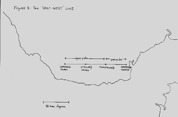
Let me give you just one preliminary example. We can draw a line on the map across the Vale of Glamorgan that runs exactly East-West and which passes through the great Tinkinswood Burial Cairn at St Nicholas. We find that three other sites - probably of Neolithic origin - lie on this line. These are the sites of Llandough Church, St Hilary Church and Llandow Church. Tinkinswood lies halfway between Llandough and St Hilary. But the surprising thing is that the distances between each of these sites are each 7.5km giving us a total line length of 22.5 km.* I shall return to the significance of these distances in a moment.
*(To be exact, St Hilary Church is not quite where it should be, being north and west of the required spot by about 75 metres. This is because the church forms part of a second alignment of four churches (St Hilary, Flemingston, St Athan, Gileston) this time running North-South. This doesn't affect the exact 15 km spacing between Tinkinswood and Llandow).
This suggests that the sites on which the churches are built are related to the Tinkinswood site. It is stretching credulity to imagine that the builders of these late middle aged churches, with all the hostility toward the pagan that there was at that time, would have sought to link their constructions with a Neolithic Burial Cairn. Moreover, we know that churches were frequently built on sites previously used for sacred purposes.
Chance might have given us a line of four sites, or the precise East-West direction of that line, or even, at a pinch, the regular distances on that line - but to suggest that the whole four site structure occurred in that way by chance is beyond credulity. The conclusion therefore is that someone laid out this design and measured these spacings over 22.5 kilometres. Would this have been possible without writing?
Historical
I have been looking at Neolithic sites in the Vale of Glamorgan for some twenty years. I was living then in Colwinston, a Vale village. My children went to a church school that drew pupils from two neighbouring parishes - Llysworney and Llandow.
Happening to be studying the Ordnance Survey map one day, I noticed that Colwinston and Llysworney churches were each an identical distance from Llandow church. Nothing terribly remarkable in that you might think, except that I couldn't help noticing that the triangle made by the three churches aimed itself directly at Nash Point, a prominent coastal feature.
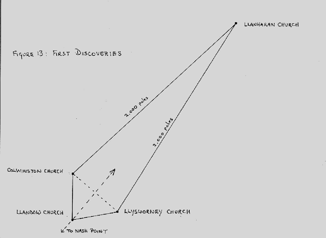
Projecting the line to Nash Point in the other direction I found that it passed through Llanharry church. Again, this could all be coincidence. But then I measured the distance between Colwinston and Llanharry, and between Llysworney and Llanharry.
These distances were exactly 10 kilometres.
I looked for, and found, a number of similar sorts of alignment. I discovered that many distances between sites could be measured in whole numbers of kilometres. I have already mentioned the 15 km Tinkinswood- Llandow distance and many other instances of this distance occurred, as did 5 kilometres and 10 kilometres.
Now clearly the Neolithic people did not measure in kilometres so it clear that whatever measuring unit they used must have had a common root with the kilometre.
Measuring the Circumference of the Earth
The kilometre is related to the circumference of the earth which is judged to be (or was when the kilometre was defined) 40,000 kilometres. So we are faced with the intriguing hypothesis that the Neolithic people used a measure that was also based on the circumference of the earth.
This poses two questions: what might such a measure have been? And secondly, if the Neolithic people did in fact use a measure related to the circumference of the earth, how could they have measured the earth?
Let us take these questions in turn. Suffice it to say that I found that the measure now known as the 'rod, pole or perch' and which is fixed in the Imperial System of measure as a quarter of a chain or 198 inches, came very close to being a potential candidate. There are in fact 198.8 such Imperial poles in a kilometre. This pole is therefore too long by about 1 per cent.
However, if we suppose that the pole in Neolithic times was not 198 inches but 196.8 inches then the pole measure fits exactly. We find that there are 8 million poles of this length in the earth's circumference (defined as 40,000 kilometres).
It is important to remember that the Neolithic pole existed before the Imperial system was devised. If the pole were to fit other measures such as the yard, derived from a different base, then it would need to be adjusted. Such length changes when one measure is 'fitted' to another system, occurs quite frequently in the history of measurement. The yard, for instance, was shortened to 36 inches and the foot to 12 inches in medieval times.
Taking, then, the Neolithic pole as 196.8 inches we find that there are 200 poles to the kilometre - and hence the correspondence between the ancient measure and the modern kilometre. 10 kilometres becomes 2000 poles, 7.5 kilometres becomes 1500 poles, 5 kilometres becomes 1000 poles and so on.
The Acre
Some evidence that helps to confirm the pole as a measure related to the circumference of the earth comes from the acre, defined as 160 square poles. This is, of course, a unit of spatial measurement still in use today. It also is a very old measure. Few would believe that it, too, is related to the earth's dimensions and not just because of its relationship to the pole.
We know it is a very old measure because certain Neolithic sites - Stonehenge for example - are constructed so that the areas of their circles, measured in acres, bear a simple relationship to each other.
For instance, the Heel Stone circle at Stonehenge - that is the outermost circle - has an area of 5 acres (and, incidentally) a perimeter of 100 poles. The Aubrey circle has an area of 1.5 acres; the Sarsen circle, a fifth of an acre and the Bluestone circle, a tenth of an acre. Counting from the inside we therefore find simple ratios of 1:2:15:50.
Some people hold that the Megalithic Yard of 2.72 or 2.73 feet to be the Neolithic unit of measurement. This is derived from measurements made at a number of Neolithic sites.
But those who promote this unit do not appear to have looked at area measures. Yes, you can measure Stonehenge linearly in Megalithic Yards (though I contend that the Megalithic Yard is no more than one sixth of a 196.8 inch pole) but not spatially.
But how, you might ask, is the acre related to the earth's circumference?
The answer is that if we take the earth's circumference (C) as 8 million, then there are exactly 100,000 times the number of acres on the land and marine surface of the earth as there are poles in the earth's radius. This is a very simple calculation to make from the respective formula for the circumference and area of a sphere.
Moreover, the fact that the acre was chosen to be 160 square poles means that it is possible to derive a simple rule of thumb for estimating the area of a circle whose radius is expressed in poles, without having to resort to π. To obtain the area (in acres) of a circle, whose radius is expressed in poles, simply square the radius, double it and divide the result by 100.
In the example of the Stonehenge Heel Stone circle (radius 16 poles) we have: radius squared = 256. Doubling this produces 512. Dividing this by 100 gives 5.12. This compares with 5.03 acres derived from using the conventional formula using π.
We can thus show that both pole and acre are measures found in and between Neolithic sites and we can show that both are related to each other and to the circumference of the earth.
Again I ask whether it would have been possible to devise such interrelated measures, based on the earth's dimensions, without the ability to write?
Whence Cometh the Pole?
You may ask 'whence cometh the pole?' It is a good question - but incidentally a lot easier to answer than 'whence cometh the Megalithic Yard, for which I have yet to find any convincing explanation? I have said that I believe the pole is based on the circumference of the earth. But one eight-millionth part of the earth's circumference is not a very practical measure. Who would be equipped to work backwards to produce a pole rod from the earth's circumference?
Clearly what was needed was a measure, related to the earth's circumference, but one pole in length.
I believe that the Neolithic people found such a measure and moreover the place where they found it was the Vale of Glamorgan. Which is one of the reasons why I believe that writing may have originated specifically in the Vale of Glamorgan.
But what could such a measure be? I believe it was the 'hump' caused by the curvature of the surface of the earth, measured across the Bristol Channel. Hence the connection with the Vale of Glamorgan. We may believe on a calm day that the sea is level, but of course it isn't. It follows the contours of the earth. And those contours are curved. There is a 'hump' in the middle and we can measure that 'hump.'
Measuring the Earth's Circumference
Now before we get too far into a discussion about the curvature of the surface of the earth, let us dispose quickly of the myth that the early people thought the earth was flat. This is in fact not an old idea at all, but a modern one deriving from the early church, which had its own reasons for advancing the flat earth notion.
Any intelligent race of people would surely have concluded that the earth was a sphere. They could see the moon and must have noticed how on certain days one can see that the characteristic crescent is formed by partial illumination of something that looks to be spherical. Someone might have looked at the sun shining on an egg and noticed the same effect.
These early people would have also looked at the horizon and noticed the curvature. They would have observed how objects (boats or islands) appear to dip below the horizon. They would perhaps have wondered, were the earth actually flat, what would have happened to the water. In short, one has to be both singularly stupid and credulous to believe the earth is flat.
So having concluded that the earth was round, and probably a sphere, how might they have measured its curvature? This is indeed a most interesting question. And one to which we do not know the answer. Or at least not yet.
What we can say, however, is that the 'hump' caused by the earth's curvature in the Bristol Channel varies between one and two poles according to the width of the Channel. Significantly, a mathematical friend, Lloyd Lee, has suggested to me that the 11.3 kilometre distance between Brean Down and Lavernock Point gives rise to a 'hump' of exactly one pole (5 metres).
Measuring the Hump
The Bristol Channel offers certain advantages when it comes to measuring the 'hump' caused by the curvature of the earth. First, the water gives you a level datum line, or rather, since the water will rise and fall with the tide, a series of datum lines.
The Channel also runs more or less east-west, which means that the sun (shining north- south) can be reflected across it. Using a reflected beam of light that just skims the surface of the water in the middle of the Channel one can thus observe the height of the 'hump' above the shoreline water level.
It doesn't matter whether the light shining between reflector and observer is strictly level as the readings from each side would be combined and averaged. The rising and falling tide confers the advantage of being able to set up the sight line, waiting until the rising tide cuts it off, and then measuring on each shore the progress of the incoming tide up the beach.
This would give you the height of the 'hump,' and from measuring the 'hump' in various places the circumference of the earth can be calculated.
But to do this requires fairly complex mathematics. It also requires a great deal of thought and planning. Recordings have to be made and preserved. And all this would surely have required writing.
No other parts of the British Isles appear to offer comparable advantages to the Bristol Channel which is why I suggest this is a particular reason for supposing that writing could have originated here in the Vale of Glamorgan.
To those who suggest that the Neolithic people could not have measured the circumference of the earth I can only ask how then do we account for all these distances between Neolithic sites that are clear fractions of the earth's circumference? To suppose that the correlation to the kilometre appeared by chance is surely stretching credulity.
But Why?
Yet supposing we can show that it is indeed possible to calculate the earth's circumference in this way, the question remains, why should the Neolithic people have wanted such a complex measure? Why not simply take an arbitrary length and standardise this? After all the pole is no more or no less useful as a unit of measurement just because it is related to the circumference of the earth.
So why did the Neolithic people bother?
The answer seems to be because in the Vale of Glamorgan at least these Neolithic people were obsessed with creating alignments that were based on whole fractions of the earth's circumference.
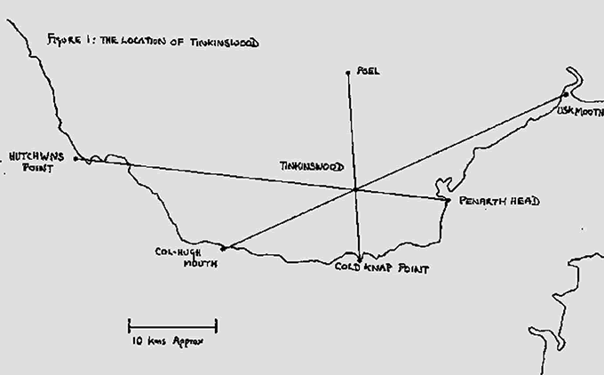
The great Tinkinswood Burial Cairn, for instance, is precisely situated at the intersection of three lines. Two of these are one thousandth of the earth's circumference in extent (8,000 poles) and the other is half of this distance - one two-thousandth in fact (4,000 poles).
Besides being one thousandth of the earth's circumference, 8,000 poles
is interesting as a distance because a circle with this radius also describes an area which is approximately one-hundred-thousandth of the total surface area of the earth.
The three lines drawn on the diagram above are by themselves fairly meaningless, so let me describe them in a little more detail to illustrate the care that the Neolithic builders put into locating the Tinkinswood Burial Cairn in what, to them, was a significant position.
The Coastal Line
It so happens (by accident) that the Vale of Glamorgan is about 8,000 poles from east to west, from Penarth Head to Hutchwns Point near Porthcawl. Today Hutchwns Point is much eroded and so the line today measures only 7850 poles.
But it is not just conjecture to suppose the line measured 8000 poles in Neolithic times. For one thing we can see the erosion that has taken place. There is also evidence from other lines that their lengths tended to be nice round whole numbers, two or three or four or eight thousand poles.
(Incidentally, this feature of Neolithic lines - many of which are or were rooted on the coast, allows us to describe the coastline as it might have been 6,000 years ago).
Even so, it is unlikely that there would have been a single unambiguous measuring point that just happened by chance to be exactly 8,000 poles from Penarth Head. No, the Neolithic people had to have a practical system of determining where such alignments began and ended.
There is evidence they did this by describing an arc whose centre was the exact end of the line and then building sites along the arc. Thus the end of the 'Coastal Line,' which today falls some 750 metres into the sea is defined by an arc of 3000 poles radius drawn on it. On this are built Llandow church and 'Yr Hen Eglws' at Nash Point and also a tumulus. There may also have been further structures to the north, but if so they have been lost beneath the steel works at Port Talbot. There are similar arcs drawn to define the ends of other alignments, as we shall see in a minute.
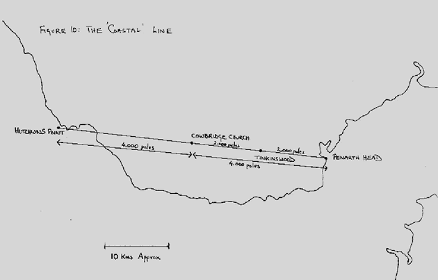
Another reason for believing the 8,000 pole length is that exactly half way along the line, 4,000 poles from Penarth Head and 4,000 from Hutchwns Point is the site of Cowbridge church, and half way between Cowbridge church and Penarth Head, 2,000 poles from each, is Tinkinswood.
There is rather more here than could have occurred by chance alone. We have not only a line of significant distance (one thousandth of the earth's circumference) but a line on which at least two important sites occur, not randomly, but at precise points, one half the way along, the other a quarter of the way along.
So far then we have seen that the great Tinkinswood burial cairn is located at the intersection of two lines - the line running due east-west and now the 'coastal' line from Penarth Head to Hutchwns Point.
But these are not the only or even the most interesting lines on which Tinkinswood is located. Two other lines have their intersection at the Tinkinswood site and for me the really fascinating fact about these two lines is that the builders of Tinkinswood located the site so that it would bisect each of these lines in the ratio of 5 to 3.
The Rivers Line
The first line is another 8,000 pole (thousandth of the earth's circumference) line running between the estuaries of the Col-Hugh and Usk rivers. Of course, you will ask, particularly in relation to the Usk estuary, how can you tell where such a line begins and ends? The answer is that 3,000 pole arc that is drawn around the origins of the line and which fixes it exactly.
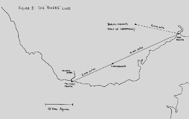
The system of arcs is particularly noticeable in relation to the mouth of the Col-Hugh river where the 3,000 pole radius arc passes through three burial cairns: Laleston, Coity and, of course, Tinkinswood itself. Having thus fixed one end of the line we can pinpoint the exact spot - now in the middle of the Usk estuary - that is the far end of the line. An arc of 3,000 poles radius drawn on this point passes through a burial mound east of Caerphilly.
Thus Tinkinswood bisects this line into a 3,000 pole (Col-Hugh-Tinkinswood) segment and a 5,000 pole (Tinkinswood-Usk) segment.
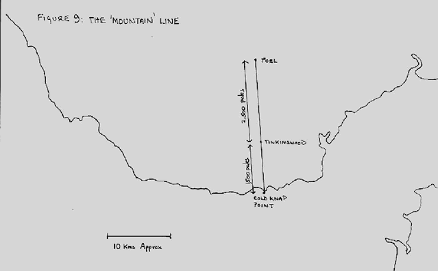
The Mountain Line
The second line is 4,000 poles long - one two-thousandth of the earth's circumference. Like the first line it connects two geographical features - this time a hill and a coastal point.
One end of the line is pretty well defined already: it is the summit of a hill called Foel, near Llantwit Fardre. Today this summit is crowned with mobile phone masts - an indication of its strategic outlook. The other is Cold Knap Point at Barry and the line passes through the Tinkinswood site on the way.
What is remarkable is that the distance between the Foel summit and Tinkinswood is 2,500 poles and between Tinkinswood and Cold Knap Point is 1,500 poles. Thus we have here the same 5: 3 ratio we find on the line between the Col-Hugh and Usk rivers.
Surveyors of the Landscape
What this means is that the Neolithic people must have been excellent surveyors.. Somehow they were able to map and measure the landscape and then to construct edifices at particular points. How they could have done this unless they possessed the ability to write is the key question.
There aren't so many situations where geographical features are found approximately 8,000 poles apart. We can presume the Neolithic people must have cast their net quite widely, mapping and measuring over large areas until they found what it was they were looking for.
But then having found a suitable location they must then have made the calculation as to where to place their lines and their burial chambers. Somehow they must have located a spot at the mouth of the Col-Hugh river and then drawn and arc around this spot over rough and undulating country, exactly 3,000 poles - 15 kilometres - in radius on which to build certain cairns. We have no idea how they might have done this.
Then they must have made the calculation of where Tinkinswood should appear on the lines they had constructed with such great precision.
And last, someone must have designed the cairns to be a certain size. Tinkinswood is reputed to have the largest capstone in Britain - much larger that many of the other tombs in the vicinity. Someone must have specified the stone avenues that surround Tinkinswood, one of which has recently been dug up and destroyed.
Which all begs the question - how on earth could the Neolithic people have done all this - the mathematics of measuring the circumference of the earth, the surveying and mapping, the calculations of lines and distances and ratios, the design and instruction to builders unless they possessed the ability to write?
Surely, writing would have been necessary and surely with evidence of these very great constructional and planning skills, writing would have been a comparatively small achievement?
Why we haven't found any writing?
Why then, I hear you asking, why then do we have no records of Neolithic writing. Why has nothing come down to us?
First, there would be nothing left if the writing were done on sticks and bones as we have evidence that other early peoples in China used to do. Such material would have long since perished.
They might, almost certainly did, make some carving on stone, but look at the ravages that a few centuries makes to inscriptions on gravestones. And here we are talking about the ravages of 60 centuries. Nor is there any evidence that the Neolithic people had tools other than flints with which to carve stone.
We also have no idea of what their writing looked like. If we came across an eroded fragment, on a stone say, would we recognise it for what it is?
I also find it hard to believe that people as sophisticated as the society that built these great monuments simply erected stones as we see them today. Would we do that?
I have no evidence whatsoever but I have a feeling that the stones we see are nothing more than the cores of something.
It would not have been very difficult after all to have enveloped a stone with a
layer of straw and wood and mud to make a type of cob plaster so that the structures we know would look rather different to how they look today. It could have been that such cob was richly decorated but the stone inside left plain because it was to be covered up.
True there are the spirals at the New Grange complex in Ireland and elsewhere. Were these decoration? Quite possibly - or were they merely there to give the cob something to adhere to?
Why though has nothing come down to us? That is easier to answer. We have this touching idea of mankind in steady progression from caveman to the sophisticated being of today. Not so. Civilisations are fragile, they bloom like flowers and like flowers they die. Our own civilisation stands ready to be wiped out - with all its wonderful technology - by a virus, or maybe by a volcanic nuclear winter, or maybe even by global warming. How much more vulnerable was the Neolithic civilisation.
If the harvests failed, or if invaders struck, or some great disease took its toll the system of writing - almost certainly the preserve of a few - could easily have died out along with those who had mastered it.
All that remains to us are the stones, enigmatic, grey and cold. I hope that in this talk I have been able to suggest that to understand the message they contain you should look not just at the stones themselves but at the spaces between the stones.
If you do this it is not hard to suppose that the stones were erected by people who possessed the Neolithic equivalent of pencil and paper. And that this particular system of writing could even have originated in Wales, in the Vale of Glamorgan, a thousand years before people began to scratch rudimentary characters into clay tablets in Mesopotamia.
Thank you for your attention.