NORTH-SOUTH LINES
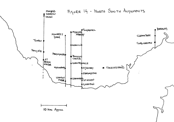
Another phenomenon that I discovered shortly after starting to work on the location of sites in the Vale of Glamorgan was the number of alignments running North-South. These are illustrated in the sketch at Figure 14.
In the Vale of Glamorgan proper there are at least four such alignments, separated by only a little over 12 kilometres. Most of these lines are aligned to hilltops. All of them host at least three churches and one hosts five. In addition there are a number of regular spacings in whole number distances that suggest careful rather than chance construction. There is also evidence that one end of these alignments was the coastline when the lines were laid out and that the lines were designed to be measured from this point. However erosion has shortened the length of the alignments today.
From West to East the four alignments are (most northerly church first):
Mynydd Caerau - Tondu Church - Pen y Fai Church - St Brides Major Church
This line has a bearing of 359 degrees to grid north and aligns with the 555 metre high trigonometrical point on Mynedd Caerau (Map Reference: SS891944). This point is 2,500 poles from Pen y Fai church. A short way below the trigonometrical point is a cairn and the distance between this cairn and Tondu church is 2,000 poles. There are two possible 'ends' to the line - 1000 poles from St Brides Church, or, more probable, 3,000 poles from Tondu. The latter gives a total line length of 5,000 poles.
Mynydd y Gaer - Church at Penymynydd - Llysworney Church - Llantwit Major Church
This line has a bearing of 355 degrees to grid north and aligns with the 295 metre high trigonometrical point on Mynydd y Gaer (Map Reference: SS954858) to the East of Bridgend. It is possible that the Church at Penymynydd was located so as to be 2,500 poles from the coast at the time the line was constructed.
Mynydd Maendy - Llanilid Church - Penllyn Castle - Llanfrynach Church - Llanmaes Church
The bearing of this line is about 358.5 degrees to grid north and the distance from Llanilid to the sea suggest that this distance was probably 3,000 poles before several thousand years of coastal erosion. The line aligns to a point (Map Reference: SS 977863) on the broad summit of Mynydd Maendy on which today stands a wind farm. It is possible for a marker cairn to have stood on this summit 1,000 poles from Llanilid Church.
Both the churches at Llanfrynach and Penymynydd (see above) are unusual in being isolated and not surrounded by obvious signs of settlement. This helps to confirm their authenticity as being established on former ancient sites. Why otherwise build a church in a place remote from houses and people? This line also passes through Penllyn Castle - a fortified house - which may, quite possibly, occupy a former ancient site.
Tonyrefail Church - St Hilary Church - Flemingston Church - St Athan Church - Gileston Church
This remarkable line of 5 churches extends over some 4,500 poles (22.5 kilometres). However it is not easy to be precise about what, if any, summit this line aligns to. Like the other lines in this series the bearing is a fraction west of true grid north (359 degrees) but, unlike the other lines, the distances between the sites are far more regular. Thus Tonyrefail ( Map Reference: ST013883) is 3,000 poles from St Hilary which itself is located approximately 1,500 poles from where the coastline might have been 6,000 years ago. Moreover, the distance between the sites of St Athan and Gileston churches is an exact 200 poles, while the distance between Flemingston and St Athan Churches is about 400 poles.
Bassaleg Church - Cleppa Park Burial Chamber - Coed Kernew Church
This line is not in the Vale of Glamorgan proper but further to the East, near Newport. It is a short line about 1,500 poles from Bassaleg church to where the sea might have been 6,000 years ago and appears to align not to a hilltop but to the mouth of a stream that drains out of the Wentlooge. The bearing of the line is 002 degrees to grid north and thus it differs from the four lines above in lying at an orientation to the east of north. Bassaleg Church (Map Reference: ST277871) is situated 400 poles north of the Cleppa Park Burial Chamber. The other distances are not regular.
BACK:Home Page and Index
MORE DETAIL:
The Pole - an Ancient Unit of Measure